


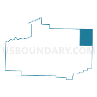
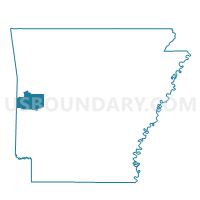
Hunt Voting District, Scott County, Arkansas
About
Outline

Summary
| Unique Area Identifier | 528080 |
| Name | Hunt Voting District |
| County | Scott County |
| State | Arkansas |
| Area (square miles) | 47.64 |
| Land Area (square miles) | 47.57 |
| Water Area (square miles) | 0.06 |
| % of Land Area | 99.87 |
| % of Water Area | 0.13 |
| Latitude of the Internal Point | 34.97531990 |
| Longtitude of the Internal Point | -93.75462690 |
Maps

Graphs
Select a template below for downloading or customizing gragh for Hunt Voting District, Scott County, Arkansas


Neighbors
Neighoring Voting District (by Name) Neighboring Voting District on the Map
- Dutch Creek Voting District, Yell County, AR
- Gravelly Voting District, Yell County, AR
- James Voting District, Scott County, AR
- Jones Voting District, Scott County, AR
- Lafave Voting District, Scott County, AR
- Petit Jean Voting District, Logan County, AR
- Sugar Creek Voting District, Logan County, AR
- Tate Voting District, Scott County, AR
Top 10 Neighboring County Subdivision (by Population) Neighboring County Subdivision on the Map
- Sugar Creek township, Logan County, AR (570)
- Petit Jean township, Logan County, AR (288)
- Hunt township, Scott County, AR (181)
- James township, Scott County, AR (143)
- Gravelly Hill township, Yell County, AR (128)
- La Fave township, Scott County, AR (110)
- Dutch Creek township, Yell County, AR (109)
- Jones township, Scott County, AR (99)
- Tate township, Scott County, AR (59)
Top 10 Neighboring Unified School District (by Population) Neighboring Unified School District on the Map
- Waldron School District, AR (9,473)
- Booneville School District, AR (8,038)
- Two Rivers School District, AR (7,182)
- Danville School District, AR (4,047)
Top 10 Neighboring State Legislative District Lower Chamber (by Population) Neighboring State Legislative District Lower Chamber on the Map
- State House District 61, AR (29,993)
- State House District 62, AR (27,262)
- State House District 84, AR (25,531)
Top 10 Neighboring State Legislative District Upper Chamber (by Population) Neighboring State Legislative District Upper Chamber on the Map
Top 10 Neighboring 111th Congressional District (by Population) Neighboring 111th Congressional District on the Map
Top 10 Neighboring Census Tract (by Population) Neighboring Census Tract on the Map
- Census Tract 9501, Scott County, AR (4,943)
- Census Tract 9525, Yell County, AR (4,796)
- Census Tract 9506, Logan County, AR (3,024)
- Census Tract 9526, Yell County, AR (2,627)
- Census Tract 9503, Scott County, AR (2,019)
Top 10 Neighboring 5-Digit ZIP Code Tabulation Area (by Population) Neighboring 5-Digit ZIP Code Tabulation Area on the Map
- 72927, AR (8,701)
- 72958, AR (8,117)
- 72833, AR (4,384)
- 72842, AR (1,478)
- 72841, AR (227)
- 72838, AR (115)